Ce jeu de données contient les données CTD collectées lors de la croisière GOMBESSA 6, du 1er au 12 juillet 2021, en Corse, Méditerranée occidentale, conjointement par les équipes Andromède océanologie (France) et MARBEC MARine Biodiversité, Exploitation et Conservation (France).
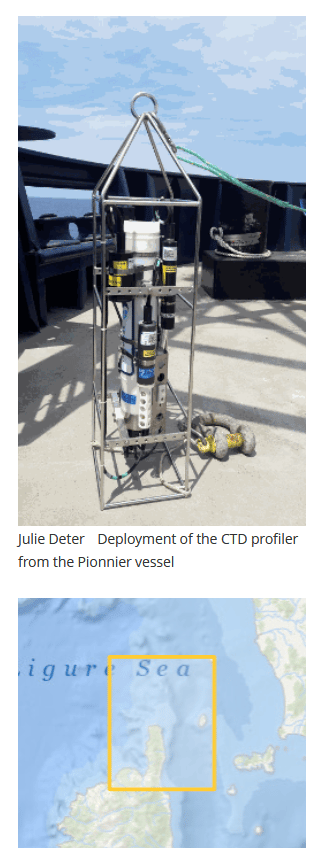
Les profils CTD pleine profondeur ont été réalisés à l’aide d’un CTD autonome SeaBird SBE 19plus V2 SeaCAT Profiler, depuis le navire Pionnier appartenant à Seaowl France et affrété par la Marine nationale française.
Neuf stations, de la profondeur de 115 m à la surface, ont été échantillonnées au large des côtes de la Corse (bassin méditerranéen occidental) entre la latitude 43.11-43.74 °N et la longitude 9.49-9.52 °E.
La fréquence d’acquisition était de 4 Hz. La précision, spécifiée par le fabricant, était de ± 0,005 °C pour la température et de ± 0,0005 S/m pour la conductivité. Le jeu de données est fourni dans différents formats (CSV, NetCDF, collection Ocean Data View), qui contient, pour chaque station, les paramètres suivants :
Profondeur [eau_salée,m]
Température [ITS-90,deg-C]
pH
Salinité, Pratique [PSU]
Conductivité [S/m]
Densité [kg/m^3]
Oxygène [mL/L]
Oxygène [% saturation]
Oxygène [umol/L]
Turbidité [NTU]
Fluorescence [mg/m^3]
Lumière [PAR/Irradiance]
CQ (référence : Drapeaux de qualité OceanSITES http://www.oceansites.org/docs/oceansites_user_manual_version1.2.doc)
Jours juliens et heure UTC (yyyy-mm-ddThh:mm:ss.sss)
| [English version] This dataset contains the CTD data collected during the GOMBESSA 6 cruise, from 1 to 12 July 2021, in Corsica, western Mediterranean, jointly by the Andromède océanologie (France) and MARBEC MARine Biodiversity, Exploitation and Conservation (France) teams. The full-depth CTD profiles were performed using an autonomous SeaBird SBE 19plus V2 SeaCAT Profiler CTD, from the Pionnier vessel belonging to Seaowl France and chartered by the French Navy. Nine stations, from the depth of 115 m to the surface, were sampled off the Corsica coasts (western Mediterranean basin) between latitude 43.11-43.74 °N and longitude 9.49-9.52 °E. The acquisition rate was 4 Hz. The accuracy, specified by the manufacturer, were ± 0.005 °C for temperature and ± 0.0005 S/m for conductivity.The dataset is provided in different formats (CSV, NetCDF, Ocean Data View collection), which contains, for each station the following parameters:
|